Pilot Mountain Trail Running and Hiking Routes
Pilot Mountain State Park in North Carolina is a popular place for hikers and runners, and is one of my favorite spots. It is close to Winston-Salem and has a very distinctive profile that lends it nicely as a landmark for navigation, and can be easily seen from some places in the Blue Ridge Mountains.
NOTE! THIS POST INCLUDES AFFILIATE LINKS (*). IF YOU MAKE A PURCHASE USING ONE OF MY LINKS I GET A SMALL (AT NO COST TO YOU!) COMMISSION OR DISCOUNT. I PROMISE TO ONLY LINK PRODUCTS THAT I'D RECOMMEND AND USE MYSELF. I STRONGLY ENCOURAGE YOU TO FIRST CONSIDER SHOPPING SMALL AND LOCALLY, EVEN IF IT MEANS I DON'T GET THE REFERRAL COMMISSION. OTHERWISE I REALLY APPRECIATE YOUR SUPPORT: BLOGS ARE EXPENSIVE TO RUN AND MAINTAIN AND I'D LIKE TO GET OUT OF THE RED ONE OF THESE DAYS, THANKS!

A view of Big Pinnacle from the Little Pinnacle overlook in October 2011
About Pilot Mountain State Park
Pilot Mountain is part of the Sauratown mountains, named for the tribe known as “Saura,” “Saraw,” or “Cheraw” — a Siouan tribe that was decimated from the area by 1720 via raids from Iroquoian tribes to the north and epidemics after contact with European settlers and consolidation with the southern Catawbans. The Sauratown mountains — which includes the peaks at Hanging Rock State Park — rise distinctly from the rest of the North Carolina piedmont due to hard metamorphic rock that resists erosion. These mountains were once ancient sandy quartz beaches along the Iapetus Ocean. Over time, these sandy beaches were buried deep below other rocks, and were then compressed and metamorphosed into hard quartzite when two ancient land masses (Gondwana and Laurentia) collided multiple times between 460 and 270 million years. The final collision — the Alleghanian orogeny — gave rise to the Appalachian Mountains and the Sauratown Mountains. While the mountains are a fraction of their once lofty heights, and the surrounding mountains have been eroded over the millions of years, the hard quartzite heart of Pilot Mountain remains. (Source: Exploring the Geology of the Carolinas* - affiliate link! - see citation below)
The Sauratown Mountains offer a unique perspective over the piedmont of North Carolina. On clear days you can see Winston-Salem to the southeast, and the Blue Ridge escarpment where the Blue Ridge Mountains rise sharply from the piedmont towards the northwest.

Pilot Mountain has a very distinct profile, making it easy to identify from a distance. View from Highway 52 heading towards Pinnacle, NC (taken in Oct 2011)

A climber tick selfie! From Oct 2020 (climbing turned out to be a great pandemic activity)
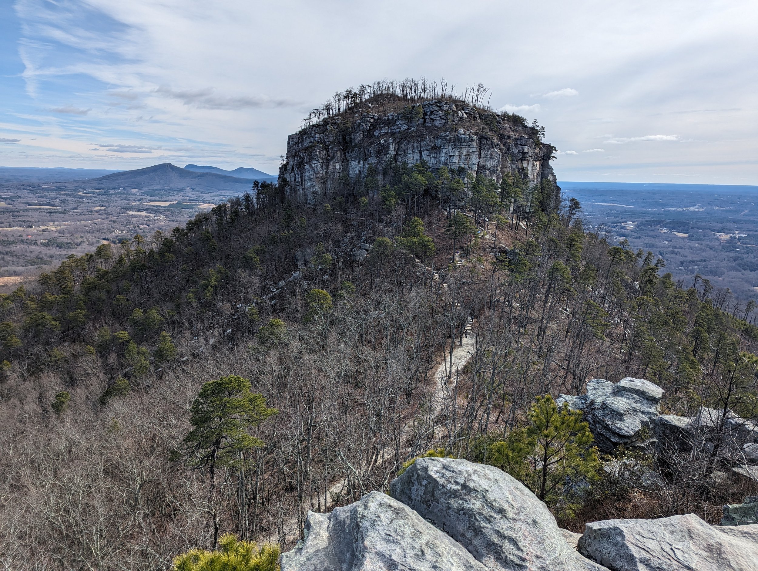
The hard quartzite of Pilot Mountain has resulted in some of the best climbing in central North Carolina and includes a saddle summit of Big Pinnacle (which is encircled by Jomeokee Trail, though the state park website now calls it Pilot Knob Trail - see note at end of post) and Little Pinnacle (which is adjacent to the parking lot and has an overlook area). The summit parking lot is very limited and is usually filled with climbers getting an early start, but there’s a significant amount of parking at the Visitor’s Center at the base of the mountain. The Visitor’s Center is relatively new and was opened in fall 2020, and offers a gift shop and information on the area. Shuttle services from the Visitor’s Center have been offered in the past, but now appear to be discontinued. Call the park for more information prior to your visit.
The actual summit of Big Pinnacle is strictly off-limits to the public; it has sheer cliffs rising up from the Jomeokee/Pilot Knob Trail, and has thin, fragile, rocky soil that supports rare montane ecology. The cliffs are also a nesting site for Turkey Vultures and Common Ravens (which are a Watch List species in North Carolina). Historically there have been some records of peregrine falcons nesting at Big Pinnacle, although currently the most eastern nesting site for peregrine falcons is at nearby Moore’s Knob at Hanging Rock State Park.

Cliffs at Big Pinnacle. You’ll usually see some vultures here.

Cliffs at Big Pinnacle. You’ll usually see some vultures here.

View of Hanging Rock State Park (second ridge in the distance) and Sauratown Mountain (private mountain with the radio tower) from Big PInnacle
Pilot Mountain has a max elevation of 2,421 feet above sea level, and rises about 1,400 feet above the surrounding terrain. Because of this and the well-maintained state park trail system, it offers some quality running and hiking routes. While any of the individual trails in the state park are well worth a visit (and the 0.8 mile Jomeokee Trail/Pilot Knob Trail is a great option for little kids under the watchful eye of a parent/guardian), I have a couple favorite options for those seeking a good training route.

A view of Big Pinnacle from the Little Pinnacle overlook in September 2023. A wildfire ravaged the mountain in 2021; if you compare this pic to the 2011 pic earlier in the blog post you can see the difference in tree vegetation, especially atop Big Pinnacle.
Route 1 - The Pilot Mountain Loop
Want a fun loop that hits the highlights and gives you the most variety of ecosystems and trail conditions? Do you like to keep your summits to a “one and done” sort of scenario? Do you relish the possibility that you might see horses? Then the Pilot Mountain Loop is for you!
By The Numbers
Distance: 9.9 miles or 10.5 miles (two variations recommended)
Vertical gain: 1,869’ (for 9.9 mile option) or 2,004’ (for 10.5 mile option)
Getting there: You can start at the Visitor’s Center (bathrooms and amenities available) or at the Culler/Pinnacle Hotel Road parking lot (just a pit toilet here, gravel lot with horse trailer access)
Route Type: Loop
Option 1:
Option 2:
The Mountains-to-Sea Trail segment 7 runs from Pilot Mountain to Hanging Rock and is about 37 miles long. Along this route is the Corridor Trail, which is a 6.6 mile horse bridle trail that runs from the Hauser Road parking lot at the Bean Shoals area to the Culler/Pinnacle Hotel Road parking lot at the base of the mountain. The MST skirts the base of Pilot Mountain via the Mountain Trail in a large oxbow before the MST continues along the Sauratown Trail to Hanging Rock. The Sauratown Trail is a bridle trail that passes through mostly private land, though there are some country road sections to connect everything (this may be variable over the years depending on conditions and land agreements).
While it’s certainly a great option to explore part or all of the Corridor Trail and Sauratown Trail, the first route I’d recommend is the Pilot Mountain Loop. There are two variations on this loop: the first is 10.5 miles and includes the Grassy Ridge Trail; the second option is just shy of 10 miles and skips Grassy Ridge Trail.
In either case, you can start at the Visitor’s Center (bathrooms and amenities available) or at the Culler/Pinnacle Hotel Road parking lot (note: just a pit toilet here). Follow the Mountain Trail (red blaze, with the Grassy Ridge Trail - yellow squares blaze - variation as an option) either clockwise or counterclockwise. When you connect with the Grindstone Trail (blue blaze), head up to the summit (this will be a left or a right, depending on which direction you’re doing the Mountain Trail loop, but when in doubt, go in the direction that goes up, it should be pretty obvious). From Grindstone Trail, I recommend taking a jaunt along Ledge Springs Trail (yellow circles blaze). You could take Grindstone Trail straight to the summit, but Ledge Springs Trail gives you some really lovely technical terrain as it skirts along the cliffs of Little Pinnacle and the climber area. Keep an eye out for climbers (make sure you step behind anyone belaying, rather than under their rope) and just be courteous here. It’s steep, it’s gnarly, and it’s popular, but it’s worth the adventure. Eventually you pop out of the climber area and onto the Jomeokee Trail (now called Pilot Knob Trail - red squares blaze) which circles the base of the Big Pinnacle cliffs. After a lovely jaunt with 360 degree views here, head to the summit parking lot with a short detour to the Little Pinnacle overlook and capture that iconic picture of the summit. Bathrooms are available at the summit parking lot if you need a quick bio break or water bottle refill! Pop across the parking lot and back onto Grindstone Trail and grind your way down down down until you connect again with Mountain Trail to continue going clockwise or counter clockwise back to your car.
There are some decent rolling climbs along the Mountain Trail, but the really fun part is the climb up Grindstone and Ledge Springs to the summit. Just remember that what comes up must come down, so hang in there and have fun!

The Mountain Trail follows rolling terrain at the base of the mountain

The Mountain Trail (red blazes) coincides with the Mountains-to-Sea Trail (white blazes) for most of the loop

Depending on the time of year, you may encounter different flora and fauna, including the native pokeweed berries

On a clear day you can see Winston-Salem!

Everyone, sing it with me now: “It’s the cliiiiiiiimb!”

Ledge Springs Trail leaving the climber area and about to connect to Jomeokee/Pilot Knob Trail
Route 2 - Pilot Mountain Repeats
Want to skip the green tunnel and the rolling route? Do steep climbs and long descents make your heart thrill with excitement? Got a gnarly mountain race coming up? Or do you just have a penchant for pain? Then the mountain repeats option is for you, my friend!
By The Numbers
Distance: 7.25 miles (out-and-back as one repeat)
Vertical gain: 1,619’ (and it’s pretty much all in the first 4 miles)
Getting there: Start at the Visitor’s Center (bathrooms and amenities available)
Route Type: Out and back

Pilot Mountain Visitor’s Center
This one is pretty simple: start at the visitor’s center. Run to the summit. Come back down. That’s one repeat - 7.25 miles and 1,619’ gain. Do as many of these as you please!
You’ll pick up the Grindstone Trail (blue blaze) right across from the Visitor’s Center (look for that telltale crosswalk). Along Grindstone Trail you’ll pass the summit road and a couple former overflow parking lots along the way — just keep looking for that blue blaze and you’ll find it. Around 2.25 miles in you’ll come to a fork in the trail. I recommend taking the right fork to get the gnarly fun of Ledge Springs Trail (same caveats apply as above — this will take you through the climbers’ area. It’s steep. It can be busy. It’s technical. Be courteous and don’t step under or on any ropes.) Huff and puff your way up to Jomeokee/Pilot Knob Trail, and do the fun loop at the base of Big Pinnacle cliffs. Check out the overlook at Little Pinnacle, get a bathroom break/water refill at the summit parking lot, and then take Grindstone Trail (blue blaze that connects on the opposite side of the summit parking lot) and head down down down.
Rinse and repeat as needed.
Tell your glutes and quads that “Liz says ‘hi!!’” ;)

Start here at the road (peep that crosswalk to access the trail). Run up to that pinnacle. Run back down. Ta-da!!
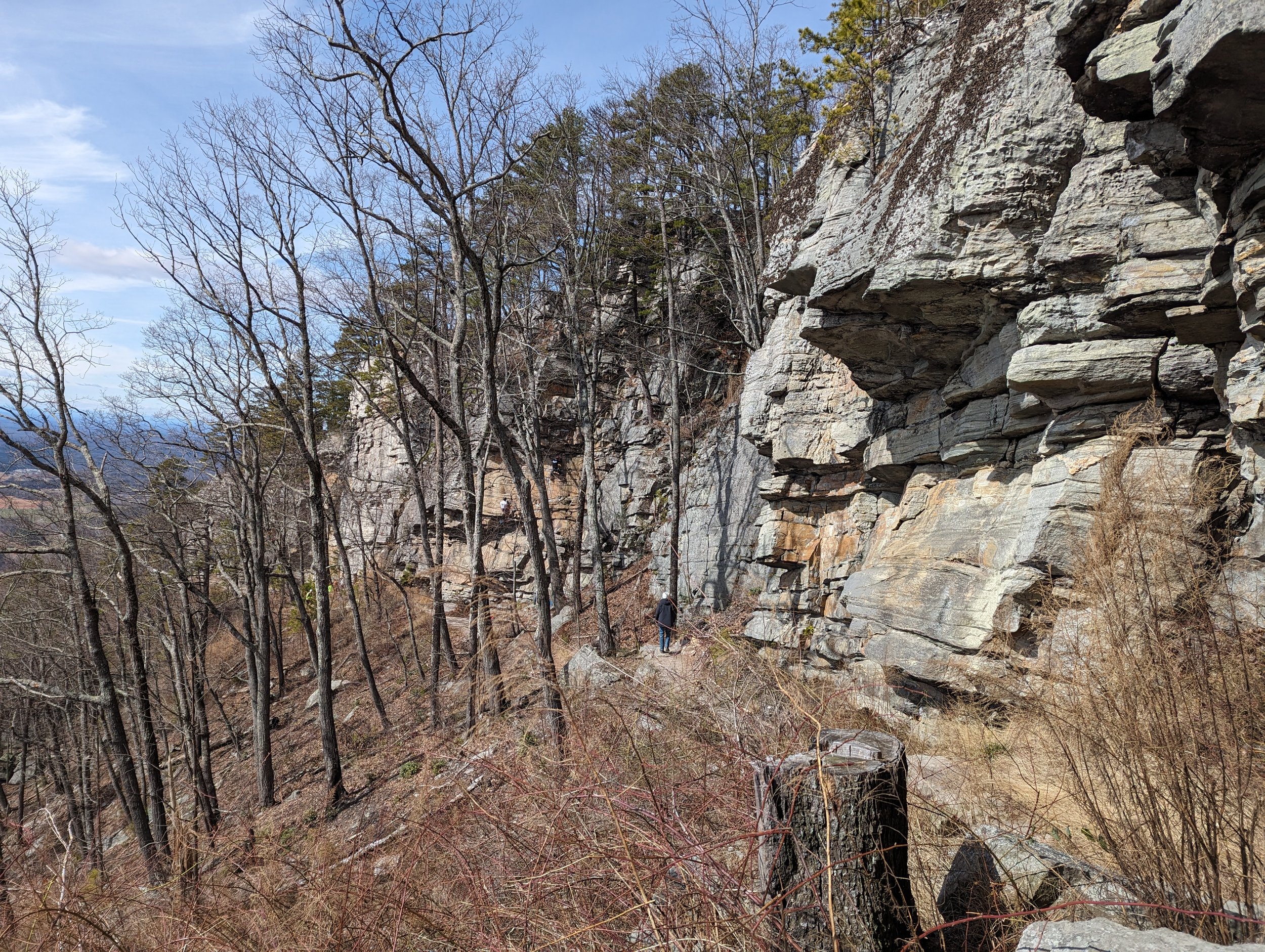
They don’t call it “Ledge Springs Trail” for nothing. This is just past the most popular routes along the climber area (you can see at least one climber on a route in the distance). There’s a nice spring at the base of Ledge Springs Trail, and if it’s rained recently water will drain down the rock cliffs.

The Jomeokee/Pilot Knob Trail (heading clockwise from the junction)

At the fork of Jomeokee/Pilot Knob Trail, you can see the saddle summit and the Little Pinnacle overlook

Steep stone stairs right before you pop out at the summit parking lot and Little Pinnacle overlook
Don’t forget to snag the iconic pic of Big Pinnacle from the Little Pinnacle overlook! This was taken in February 2024; in winter you can clearly see where the Jomeokee/Pilot Knob Trail goes along the saddle summit
Note: I’m not sure when and why they changed the name from “Jomeokee Trail” to “Pilot Knob Trail” but since you may still find resources that reference the old name, I’m using both throughout this post. I’ve always heard that “Jomeokee” means “great guide” or “pilot” in the Saura language, but I assume there’s some nuance and complexity behind the story. If anyone has more information, please feel free to reach out! Otherwise I may inquire and possibly do a blog post on this topic in the future.
Sources:
Stewart, Kevin G., and Mary-Russell Roberson. Exploring the geology of the Carolinas: A field guide to favorite places from Chimney Rock to Charleston (*affiliate link). Chapel Hill, NC: Univ. of North Carolina Press, 2007.
“Lower Saratown.” Ancient North Carolinians: A Virtual Museum of North Carolina Archaeology. Accessed February 18, 2024. https://ancientnc.web.unc.edu/indian-heritage/by-time/historic/lower-saratown/.
Meredith Barkley Staff Writer Reidsville -. “The Saura Indians Met a Silent End.” Greensboro News and Record, June 24, 1992. https://greensboro.com/the-saura-indians-met-a-silent-end/article_578cb1ad-99e4-5446-8c5e-9935d1185c97.html.
Have you ever been to Pilot Mountain State Park in North Carolina? Do you have a favorite hiking or running route here? Let me know in the comments!


Global Running Day is always the first Wednesday in June, and for five of the last seven years, I’ve been at the 5K and kids’ run put on by my local Fleet Feet — one year as a runner, four years as a photographer.